Itineraries
Historic Sites
The Connecticut River rises in a little pond known as Fourth Connecticut Lake on the Canadian border, and there begins as a mere trickle its 410-mile journey to the se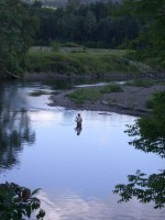 a. It proceeds through a series of lakes in a dense, spruce fir forest populated with moose and other woodland creatures. It’s still just a narrow stream where it reaches the town of Colebrook, NH, perched on the banks in the shadow of Monadnock Mountain rising on the Vermont shore. The proud people of the region – who once formed an independent republic early in the 19th century – continue the traditions of outdoor life represented by logging and backwoods recreation, where a short drive can take you over the border into another state or another country altogether.
Colebrook is the Waypoint community for an area that includes Pittsburg, Clarksville, Stewartstown, Dixville, Columbia, and Stratford, NH, and Canaan, Lemington, and Bloomfield, VT. Its visitor center is located on a scenic bend of the Connecticut on Route 3, 1.5 miles north of Colebrook’s downtown. The Center includes exhibits about local history and events.
The designated Byway routes in the Colebrook area are Routes 3 and 145 in New Hampshire and Route 102 in Vermont.
Nature and Scenery
 The headwaters of the Connecticut River at tiny Fourth Lake located on the Canadian border and accessible by a footpath created by The Nature Conservancy. Which of several pond outlets actually becomes the river depends on the mood of resident beavers. Third, Second, and First Connecticut Lakes are next in the chain, followed by Lake Francis. All offer fine, deep habitat for a renowned fishery that includes landlocked salmon and lake trout. In Pittsburg, a town larger in area than the state of Rhode Island, Route 3 links the lakes and is a prime moose watching corridor.
Beaver Brook Falls in Colebrook is picturesque in all seasons, including winter, when its accumulation of ice is a spectacular sight.
The Connecticut’s exceptional natural beauty in this area was recognized by an act of the New Hampshire legislature in 1992. The legislature designated as “natural” the seven mile stretch of the river from the mouth of Wheeler Stream across from Columbia to the c. 1885 steel truss bridge between Stratford and Maidstone, the only segment of the Connecticut so named.
From Stratford to Gilman, the river shifts from quick water to meandering across a valley of rich soils, taking shortcuts during high water and creating oxbows. In one place, a Vermont farmer can watch the sun set over New Hampshire.
In the northeastern corner of Vermont, the 72,000-acre Nulhegan River basin is a complex of bogs, freshwater wetlands, and spruce fir forest. It provides nesting habitat for loons, hooded mergansers, black, ring-necked and wood ducks. At least 13 rare plant and animal species have been recorded from this site, which site has the only viable population of spruce grouse in the watershed. It also provides extensive contiguous forest for breeding migrant birds. The Silvio O. Conte National Fish and Wildlife Refuge has named the Nulhegan basin a special focus area, and manages the habitat there in partnership with the state of Vermont and other adjacent landowners.
Farming
Roadside signs in Stewartstown and Clarksville mark the 45th parallel, halfway between the Equator and the North Pole. Despite the short growing season this far north, farming is a cherished way of life for many families. Old-fashioned county fairs are held in the area.
History and Culture
The 1783 settlement that ended the Revolutionary War set off a boundary dispute involving the U.S.-Canadian border. Here in northern New Hampshire, residents finally took things into their own hands in 1832 by declaring themselves the United Inhabitants of Indian Stream Republic. They drafted a constitution and created a militia – of 41 men. But they couldn’t agree among themselves about whether to form an alliance with Great Britain or the United States, and civil war seemed likely. When the New Hampshire Assembly proposed the Republic become part of New Hampshire, it agreed. In 1840 the former Republic was incorporated as the town of Pittsburg.
Log trucks on the region’s roads are part of a tradition that goes back to the 19th century log drives on the Connecticut. Crews of the Connecticut Valley Lumber Company spent the winter months felling trees, and when snowmelt swelled the rivers in Spring, sent them floating on down the river. Into the first decades of the 20th century, hardy crews of “white-water men” risked life and limb in the hazardous work of floating the logs as far down river as Massachusetts and Connecticut. At pulp and saw mills the logs were processed into paper and lumber. Railroads and improved highways – and changing culture – brought the era of log drives to an end.
The Poore Family Homestead in Stewartstown, NH illustrates a way of life that existed prior to rural electrification. The protected 100-acre property displays the 1826 homestead, barns, furnishings, and tools of this early hill farm, reflecting the traditional spirit, values, and way of life of settlers of the Connecticut River Valley headwaters.
Among the historic bridges in the Colebrook area are several covered bridges. The Pittsburg-Clarksville Bridge spans the Connecticut River, and the Happy Corner Bridge and the River Road Bridge both span Perry Stream in Pittsburg. The picturesque Columbia Bridge spans the Connecticut between Columbia and Lemington.
The Arts Alliance of Northern New Hampshire supports and sustains culture, heritage and the arts in the Colebrook region with a variety of events, performances, and activities.
Colebrook and Pittsburg serve as the provisioners for recreation in the backcountry. Colebrook is proud of its numerous, if small, restaurants, and the church suppers and high school concerts and plays that take the place of movies and theaters. Colebrook celebrates its heritage with a Moose Festival in August and a Snowdeo in February.
Recreation
The Great North Woods is a mecca for those who are passionate about camping, hunting, fishing, hiking and snowmobiling. Trout and land-locked salmon may be found in the Connecticut Lakes. The Connecticut in this region is suitable for canoe and kayak. The Northern Forest Canoe Trail, a 740-mile water trail tracing historic Native American travel routes across the Northern Forest, celebrates the region’s rich human heritage and diverse natural environment. The Canoe Trail follows the Nulhegan River to its confluence with the Connecticut River in Bloomfield, and continues downstream to meet the Upper Ammonoosuc in Groveton.
The Connecticut River Joint Commissions provide maps of the river that identify river access and describe other important aspects of boating on the river. In this region, beginning with the river’s source, they include:
- The Connecticut Lakes
- The North Country
Those looking for a true wilderness trail experience will want to know about the Cohos Trail, a 162-mile remote trail in northern-most New Hampshire.
State parks in the area are numerous:
- Beaver Brook Falls Wayside, Colebrook
- Coleman State Park and Campground, Stewartstown
- Deer Mountain Campground, Pittsburg
- Lake Francis State Park and Campground, Pittsburg
Railroads
When the Great North Woods were logged in the second half of the 19th century, unique, narrow-gauge rail lines were set deep into the forest to bring out the logs. These proved as ephemeral as the old logging camps themselves, but traces of them remain in the woods as trails, or grown back up with trees. Sometimes these routes have been preserved as trails.